
The Mumbai Metropolitan Region is undergoing significant infrastructure-led expansion, with NAINA (the Navi Mumbai Airport Influence Notified Area) forming an important part of the planned development around Navi Mumbai International Airport.
This guide explains NAINA’s current Development Plan, CIDCO’s Town Planning Schemes, infrastructure framework and the key checks landowners and property buyers should understand.
Updated and verified: 3 October 2026. Planning and infrastructure information has been reviewed against CIDCO’s own notifications and official sources available as of 3 October 2026.
What is NAINA?
NAINA stands for the Navi Mumbai Airport Influence Notified Area. It is a planned urban development zone encompassing the peripheral areas around the operational Navi Mumbai International Airport (NMIA). The Government of Maharashtra notified NAINA in January 2013, appointing CIDCO (City and Industrial Development Corporation of Maharashtra) as the Special Planning Authority (SPA) to oversee its phased development.
NAINA is not the same as an established Navi Mumbai node like Kharghar, Taloja, Kamothe or Panvel city. Those are already-built CIDCO townships. NAINA is the surrounding, still-developing planning region regulated separately.
Why NAINA Was Created
NAINA was created to regulate development around Navi Mumbai International Airport and prevent unplanned growth in the airport’s influence area. CIDCO’s planning framework uses land-use zoning, Town Planning Schemes and infrastructure planning to guide development across the notified region, rather than leaving it to unregulated private development once the airport became operational.
Where Is NAINA?
NAINA’s 94 villages are in the Raigad district of Maharashtra, mostly in Panvel taluka with a small part in Uran. The 77 villages removed in March 2024 were in Pen taluka. A village name alone does not identify a parcel’s scheme or permitted use, so use the village and survey number with the official sources listed below. It forms a wide ring around the eastern and southern flanks of Navi Mumbai, sitting between the established Navi Mumbai nodes and the wider Konkan region.
NAINA Map
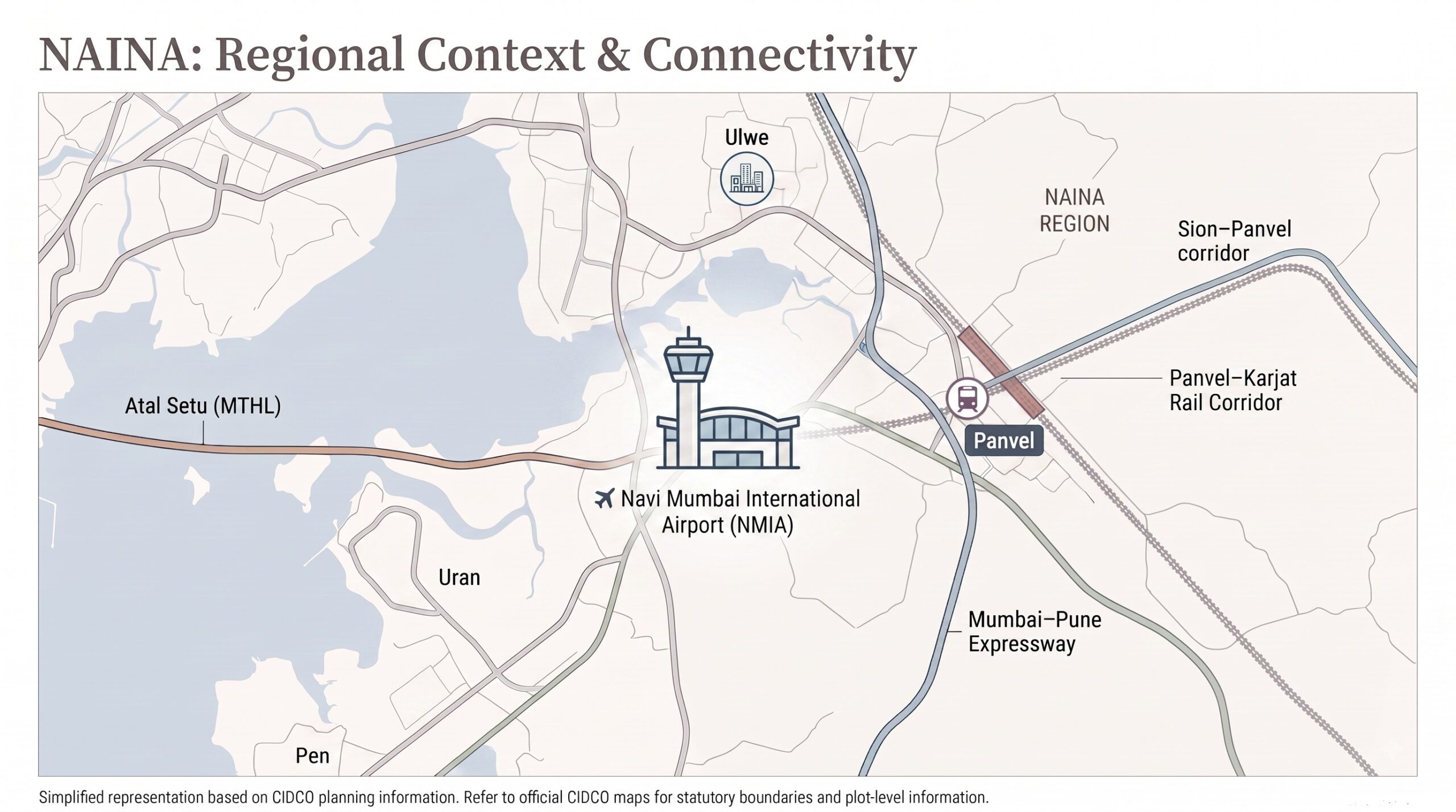
This simplified regional map shows NAINA’s location in relation to Navi Mumbai International Airport, Panvel and key transport corridors. For statutory NAINA boundaries, Town Planning Scheme boundaries and individual survey numbers, refer to CIDCO’s official planning maps.
Find the Official Map for Your Land
| What you need | Where to start |
|---|---|
| The notified area | The TPS 12 report includes plans of the NAINA notified area, and CIDCO’s NAINA overview page is the general entry point |
| The development plan for your area | CIDCO’s pages for the sanctioned NAINA Interim Development Plan and the sanctioned NAINA DCPR |
| The specific town planning scheme map | CIDCO’s index of TPS 1 to 14, then the page for the scheme covering your survey number |
| Zoning and permitted use | The sanctioned regulations on the DCPR page, read together with the plan that covers your village |
We have not confirmed which of these pages holds downloadable plan sheets for every village. A village name alone does not tell you which scheme covers a parcel or what use is permitted, so match the village and survey number against the scheme records.
How Large Is the Notified Area?
The geographical footprint of NAINA has evolved significantly since its inception to streamline execution.
- 2013: A notification of 10 January 2013 appointed CIDCO as Special Planning Authority for 270 villages, 14 in Thane district and 256 in Raigad. The notification text we read states no area. CIDCO’s FAQ says about 560 sq km, while one of its scheme reports says about 558 sq km.
- By 2017: CIDCO’s FAQ says the state reduced the area to 224 villages, about 461 sq km in that document.
- September 2019: A notification of 16 September 2019 excluded 49 non-contiguous villages. That left about 174 villages and 371 sq km, according to CIDCO’s 2026 scheme report.
- March 2024: A notification dated 4 March 2024 excluded 80 villages, 77 in Pen taluka and 3 in Uran, and included them in MMRDA’s jurisdiction. CIDCO’s TPS 12 preliminary report, drawn up on 17 November 2025 and submitted to the government on 12 February 2026, describes the reduced NAINA area as 94 villages covering about 225.59 sq km.
The 80 villages did not move alone. MMRDA’s notification of 15 October 2024 appointed it New Town Development Authority for 124 villages, about 323.44 sq km, in Uran, Panvel and Pen. The gazette says 80 of them came from NAINA, 33 from the separate Khopta New Town notified area, 2 from the Mumbai Metropolitan Regional Plan and 9 from the Raigad Regional Plan. CIDCO’s appointment as planning authority for the 80 NAINA villages and the 33 Khopta villages was withdrawn by the March 2024 notification.
CIDCO’s figures do not reconcile exactly: 224 villages less the 49 excluded in 2019 is 175, while the TPS 12 report gives 174, so we use CIDCO’s stated figures.
NAINA, KSC New Town, Mumbai 3.0 and Khopta: What Is What
- NAINA: the area CIDCO plans as Special Planning Authority, now 94 villages.
- Khopta New Town: a separate notified area, not part of NAINA. The 2024 notifications refer to 33 villages in it, and CIDCO’s appointment as planning authority for those 33 villages was withdrawn. We did not check the status of any other Khopta area.
- KSC New Town: MMRDA’s name for its 124-village, 323.44 sq km area. MMRDA is the New Town Development Authority, not NAINA’s planning authority.
- Mumbai 3.0: the name MMRDA’s press releases use for a 323.44 sq km planning area, the same size as KSC New Town. We did not find an MMRDA document that defines the two as identical, but the figures match.
- Third Mumbai: a popular label. We did not find it in the CIDCO or MMRDA documents we read.
No official source we found says that Mumbai 3.0 or KSC New Town is NAINA. KSC New Town includes 80 villages that were formerly within NAINA. Check the current notification for the village and survey number of the property you are looking at.
NAINA Development Plan: Current Status
The NAINA Development Plan (DP) is the statutory master document dictating land use, zoning and infrastructure layout. CIDCO’s NAINA Interim Development Plan (IDP) was sanctioned by the Maharashtra Government’s Urban Development Department on 27 April 2017 (notification TPS-1215/245/CR-332/2015/SM/UD-12), under Section 31(1) of the Maharashtra Regional and Town Planning Act, 1966. That sanction was partial: 82 “Excluded Portions” were held back for further processing and separate hearings, and the state government has continued issuing notifications since to sanction excluded portions as they clear review. CIDCO’s NAINA DCPR was amended in March 2024, the amendment we reviewed.
The rest of the area is covered by a separate Development Plan with its own regulations, DCPR-2019. The state partly sanctioned it by a notification of 16 September 2019 and sanctioned excluded parts of it on 24 June 2022 and 26 July 2023, according to CIDCO’s TPS 12 report. We did not establish whether every excluded part has since been sanctioned, so check CIDCO’s Development Plan page for the plan that covers a given survey number.
This phased approach means different parts of NAINA are at different planning stages, so the position depends on the village and survey number.
Town Planning Schemes (TPS) Explained
Rather than acquiring land outright, CIDCO is executing NAINA primarily through a participatory land-pooling model known as Town Planning Schemes (TPS). A TPS breaks the larger NAINA region into smaller, manageable clusters, allowing CIDCO to lay arterial roads, water supply and drainage systems cluster by cluster. CIDCO’s TPS index lists 14 Town Planning Schemes (TPS 1 through TPS 14), and they are at very different stages. The stage breakdown below comes from CIDCO’s TPS 12 preliminary report, which was drawn up on 17 November 2025 and submitted to the government on 12 February 2026, and it describes the position at that time, not today.
| Scheme information | What we can say |
|---|---|
| TPS 1 to 14 listed | CIDCO’s index lists all fourteen, with notices and awards under each scheme |
| Position in the TPS 12 report (drawn up November 2025) | The preliminary schemes of the first seven were sanctioned and in force, the final schemes of the first two were sanctioned, and sanction of the final schemes of schemes 3 to 7 was awaited. The report describes TPS 12 as a preliminary scheme submitted to the government in February 2026 |
| Later stages | The index shows further items, such as preliminary awards for several later schemes. We did not check each scheme’s status on 3 October 2026 |
| TPS 13 and TPS 14 | They appear in the index. We did not verify their stage |
Because schemes move between stages over time, check the index and the page for the specific scheme covering your survey number for its current status and the relevant notification dates.
TPS-Wise Villages and Status
CIDCO’s TPS notifications and reports name the revenue villages in each scheme, and village lists for each scheme are published on CIDCO’s TPS pages. Two examples from primary CIDCO documents: the TPS 8 draft-sanction notification (Panvel taluka, Raigad district) covers Moho, Pali Khurd, Belavali, Chikhale, Ambivali, Loniwali and Wangani Tarf Waje, and the TPS 12 report names Vakadi, Umroli, Chinchavali Tarf Waje, Usarli Budruk, Ritghar, Morbe, Kondale and Mahalungi. Spellings vary across CIDCO documents, so match your survey number rather than the name, and use the scheme page for your village.
How Land Pooling Works
The Town Planning Scheme model is a land pooling arrangement in which, according to CIDCO’s FAQ and scheme reports, owners get about 40% of their original land back as final plots, which CIDCO describes as serviced.
- Reconstitution: A TPS reconstitutes original plots under the statutory scheme. Establish the original plot, the allotted final plot, the area adjustment, the financial provisions and the applicable regulations from the scheme records.
- Land share: In CIDCO’s description, the rest of the land after the final plots goes to roads, open space, amenities and other scheme requirements. Being within NAINA does not by itself establish that a parcel is subject to a particular TPS or a uniform land deduction, so identify the scheme and the plot records before you calculate usable area.
- Final plot: The landowner receives a reconstituted final plot under the applicable scheme, with its development governed by that scheme’s sanctioned regulations. An allotment or a scheme provision does not mean that roads and utilities are already complete and available at the plot, so check what exists on the ground.
- Building permission: CIDCO’s older, informative TPS FAQ describes a restriction on processing building permission requests once a scheme is declared, because the scheme redraws plot boundaries, and says that after the draft scheme is sanctioned, owners whose final plot is substantially at its original location can seek development permission with the appointed arbitrator’s consent. That is attributed to the FAQ and is not an exhaustive current rule. Ask CIDCO for its written position on your parcel, the scheme’s current stage and its sanctioned regulations.
- Development potential: CIDCO’s 2019 TPS FAQ, which calls itself informative and not sanctioned regulations, describes an FSI of 2.5 on a final plot that is exactly 40% of the original holding, adjusted in proportion if the plot is larger or smaller. The FSI that applies to your plot depends on the sanctioned scheme and the applicable regulations, so confirm it with CIDCO.
Do not mix these figures with the voluntary “NAINA Scheme” under the 2017 regulations. CIDCO’s older NAINA Scheme FAQ describes several configurations with different area, land-sharing and development conditions, including a larger-land option in which 40% of the land goes to the project and the owner keeps 60%, a smaller-land option and a separate option for urban villages. Establish which regulation currently applies before you rely on a minimum area or an FSI figure.
NAINA Infrastructure Currently Planned/Under Development
CIDCO is currently prioritizing the physical framework of the early TPS clusters. Infrastructure planning for the NAINA TPS areas includes:
- Arterial road networks connecting villages to state highways. Construction World reported on 18 March 2024 that CIDCO had issued tenders worth about ₹3,115 crore for infrastructure in the early schemes. The Free Press Journal reported on 22 August 2024 that L&T said CIDCO had awarded it an integrated infrastructure contract valued between ₹2,500 crore and ₹5,000 crore. A tender or an award does not show that work is complete, that money has been spent or that any utility is available at a particular plot.
- Trunk utility lines: water supply, drainage and underground power ducts.
- A Comprehensive Mobility Plan (CMP), intended to integrate local transit with regional transport corridors.
Connection With Navi Mumbai International Airport
NAINA’s entire existence is predicated on Navi Mumbai International Airport (NMIA). As of August 2026, NMIA is operational: it received its DGCA aerodrome licence on 30 September 2025, was formally inaugurated on 8 October 2025, and began commercial passenger service on 25 December 2025. It moved to round-the-clock operations in February 2026 and launched international passenger and cargo services on 15 July 2026. If you’re reading older coverage that places NMIA’s opening in “late 2024/early 2025,” that information is outdated.
NAINA is designed to act as the primary support ecosystem for this aviation hub. The wider airport region also includes reported plans for a “Navi Mumbai Aerocity” commercial and hospitality district. Treat this as a proposal to track through official CIDCO and airport-region planning updates rather than a confirmed development.
Road, Rail and Proposed Metro Connectivity
NAINA is anchored by overlapping state and national transit projects:
- Atal Setu (Mumbai Trans Harbour Link): opened 12 January 2024, connecting Sewri in Mumbai to Chirle in Navi Mumbai and adding a direct road link into the wider Panvel/NAINA region. (See our Atal Setu Toll 2026 guide.)
- Panvel to Karjat suburban rail corridor: a corridor that a Free Press Journal report of 6 June 2026 described as 98% complete and not yet operating for suburban services. It is expected to strengthen rail connectivity across the eastern side of the wider Panvel/NAINA region once it opens.
- Future transit planning: long-term mobility planning for the region considers integration with the wider Navi Mumbai public transport network, including a proposed metro link toward NMIA. Treat any proposed route or timeline as indicative until officially sanctioned.
NAINA vs Ulwe vs Panvel
These three names are often compared, but they are different kinds of place with different regulatory arrangements. The table compares planning fundamentals, not prices. For any purchase, compare the exact location’s planning body, road access, water supply, drainage and nearest operating station.
| Factor | NAINA | Ulwe | Panvel |
|---|---|---|---|
| What it is | An area CIDCO plans as Special Planning Authority, covering 94 villages | A CIDCO node | A town in the Panvel Municipal Corporation area |
| Civic body | Depends on the village | We could not confirm the civic body from an official page | Panvel Municipal Corporation |
| Planning authority | CIDCO, as Special Planning Authority | CIDCO lists Ulwe among its developed nodes in its 2026-27 transfer charges circular | Historic Panvel town and CIDCO-developed New Panvel are different areas, and the planning authority can differ by address, so check the property’s own records |
| Relationship to the airport | Named for the airport influence area | Near the airport | A rail and road gateway to the region |
| Stage | Varies by village and scheme | An existing node with housing | An established town |
| Rail | No single station; depends on the village. The Panvel to Karjat suburban corridor was reported on 6 June 2026 as not yet operating for suburban services | Check the nearest operating station for the exact location | Panvel station on the Harbour Line, also a junction for long-distance trains |
What Property Buyers/Landowners Should Verify
Buying land in NAINA requires strict due diligence. It is vastly different from buying a ready apartment. Before proceeding, verify:
- Land use and conversion: is the land agricultural, and is the intended use permissible under the development plan? Under the Land Revenue Code amendment first published on 31 December 2025, no Collector permission is needed for a non-agricultural use that the Development Plan permits, but the planning authority recovers a one-time premium before it gives development permission. Our guide to buying land in Navi Mumbai covers this, the rules on who can buy agricultural land, and CIDCO transfer charges.
- TPS inclusion: does the specific survey number fall within a sanctioned or notified Town Planning Scheme, and what is that scheme’s current status directly with CIDCO?
- CIDCO permissions: does the plot have explicit CIDCO development permissions? A land deduction applies only if the parcel is within a particular scheme, so identify the scheme and the plot records before you calculate usable area.
- Sanctioned DCPR: what does the applicable Development Control Regulation say for that specific plot: actual permissible FSI and allowed land use (residential vs. commercial)?
Official CIDCO Resources
To verify zoning and scheme details, always rely on primary government sources:
- CIDCO Official Website
- CIDCO NAINA Overview
- CIDCO Town Planning Schemes (TPS 1 to 14) & Notifications
- Sanctioned NAINA Interim Development Plan
- Sanctioned NAINA DCPR
- CIDCO Preliminary Town Planning Scheme No. 12: village counts and scheme status.
- MMRDA New Town Development Authority overview: KSC New Town.
- Annual Statement of Rates (ASR): the official stamp duty valuation rates.
For related reading: Panvel vs Kharghar vs Taloja and CIDCO Lottery Guide.
The featured image is an AI-generated illustration and does not show a real location. The regional map is a simplified drawing and is not a statutory boundary. Disclaimer: Last verified 3 October 2026. Development plans, TPS boundaries, regulations and infrastructure status may change. For plot-specific information, survey numbers and development permissions, always verify the latest records directly with CIDCO and the relevant authorities.
Related Guides
- Upcoming Residential Projects in Navi Mumbai 2026: New Launches, Prices & Top Areas
- Areas in Navi Mumbai: nodes and municipal boundaries
Frequently Asked Questions
What is the meaning of NAINA in Navi Mumbai?
NAINA stands for the Navi Mumbai Airport Influence Notified Area. It is a planned urban development region managed by CIDCO, designed to prevent haphazard growth around the operational Navi Mumbai International Airport.
How much land will I lose in the NAINA Town Planning Scheme?
Not every NAINA parcel is subject to a land deduction. In a Town Planning Scheme, CIDCO’s FAQ and scheme reports say owners get about 40% of their original land back as a final plot, with the rest used for roads, open space, amenities and other scheme requirements. Being within NAINA does not by itself establish that a parcel is in a particular scheme, so the outcome depends on the sanctioned scheme and plot records for your survey number.
Is Navi Mumbai International Airport open?
Yes. NMIA began commercial passenger operations on 25 December 2025, moved to round-the-clock operations in February 2026, and launched international passenger and cargo services on 15 July 2026.
What is the FSI in NAINA?
There is no single FSI for the whole of NAINA. CIDCO’s 2019 TPS FAQ, an informative document and not sanctioned regulations, describes an FSI of 2.5 on a final plot that is exactly 40% of the original holding. The FSI for a given plot depends on the sanctioned scheme and the applicable regulations, so confirm the figure with CIDCO.
How many Town Planning Schemes does NAINA have, and which villages are included?
CIDCO’s index lists 14 Town Planning Schemes (TPS 1 through TPS 14) at different stages. Village coverage is published per scheme on CIDCO’s TPS pages, for example TPS 8 (Moho, Pali Khurd, Belavali, Chikhale, Ambivali, Loniwali and Wangani Tarf Waje) and TPS 12 (Vakadi, Umroli, Chinchavali Tarf Waje, Usarli Budruk, Ritghar, Morbe, Kondale and Mahalungi). The stage breakdown in this guide comes from the TPS 12 report of November 2025, so check the page for the scheme covering your survey number for its current status.
How many villages are in NAINA now?
CIDCO’s TPS 12 preliminary report, submitted in February 2026, describes NAINA as 94 villages covering about 225.59 sq km, after 80 villages were moved to MMRDA’s jurisdiction by a notification of 4 March 2024. The original 2013 notification covered 270 villages. That is the latest official figure we found.
Is NAINA the same as Mumbai 3.0 or the Third Mumbai?
No official source we found says so. MMRDA is the New Town Development Authority for KSC New Town, a 124-village, 323.44 sq km area, and its press releases use the name Mumbai 3.0 for a planning area of the same size. NAINA is CIDCO’s planning area. KSC New Town includes 80 villages that were formerly within NAINA, so check the current notification for the village and survey number of the property you are looking at. We did not find “Third Mumbai” in the CIDCO or MMRDA documents we read.
Can I get building permission on land inside a Town Planning Scheme?
CIDCO’s older, informative TPS FAQ describes a restriction on processing building permission requests after a scheme is declared, because the scheme redraws plot boundaries, and says that after the draft scheme is sanctioned, owners whose final plot is substantially at its original location can seek development permission with the arbitrator’s consent. That is not an exhaustive current rule, so ask CIDCO for its written position on your parcel, the scheme’s current stage and its sanctioned regulations.
Is the 40% return the same as the NAINA Scheme?
No. In a Town Planning Scheme CIDCO’s FAQ and scheme reports say owners get about 40% of their original land back as final plots. The separate voluntary NAINA Scheme described in CIDCO’s older FAQ has several configurations with different area, land-sharing and development conditions, including one in which 40% of the land goes to the project and the owner keeps 60%. Establish the currently applicable regulation before you rely on a minimum area or an FSI.
What are land prices in NAINA?
We found no official CIDCO or revenue department publication of land prices for NAINA villages. Maharashtra’s official rates are the Annual Statement of Rates, published through the e-ASR portal of the Stamps and Registration Department. They exist to assess stamp duty and are not market prices. Check the rate for your village on the portal and treat any quoted market price as a seller’s figure until you have documents.