Kalavantin Durg is a rock pinnacle beside Prabalgad in Panvel taluka, reached from Thakurwadi village. The climb combines an uphill approach, exposed rock-cut steps and, for those who go on, a separate final scramble to the top. This guide breaks the route into those parts, explains how to get to Thakurwadi from Navi Mumbai and sets out what to check before you go. It is written to help you decide how far to go, and stopping early is a good outcome.
Access arrangements, charges and conditions on the hill change and are not set out in one official notice that this guide can point to. Check before you leave, and confirm again at the trailhead. This guide is independent and is not run by any trekking operator or authority.
Kalavantin Durg at a glance
| Question | Answer |
|---|---|
| Where is it? | In the Western Ghats beside Prabalgad, Raigad district. |
| How high is it? | 2,250 ft (686 m), according to Wikipedia. |
| Where does the trek start? | Thakurwadi village in Panvel taluka. The nearest railway station is Panvel. |
| Distance | Wikipedia gives about 3 km to the summit. Sources do not agree on where that distance is measured from, or whether it is one way, so treat it as a rough figure and not a plan. |
| Best time | Dry, clear days in the cooler months. A 2024 guide names November to February. |
| Current access | Checked 22 October 2026: current opening restrictions, registration arrangements and charges have not been independently confirmed. Check applicable authority notices and local arrangements before you travel. |
How hard is it, section by section
Distance alone does not describe this trek. Wet rock, crowds, your confidence at height and the descent all change how hard it feels. This guide’s advice for beginners, children and anyone afraid of heights is to stay at the lower stages. That is a recommendation from this guide and not an official eligibility rule.
| Stage | What readers need to know |
|---|---|
| Thakurwadi to Prabalmachi | The approach trail, an ascent of about 2 km according to Wikipedia, with places to rest. This stage is a hill walk, not a climb. |
| Prabalmachi towards the pinnacle | The route forks here. One path goes to Prabalgad and the other to Kalavantin Durg, so take the correct one. The terrain changes as you near the rock. |
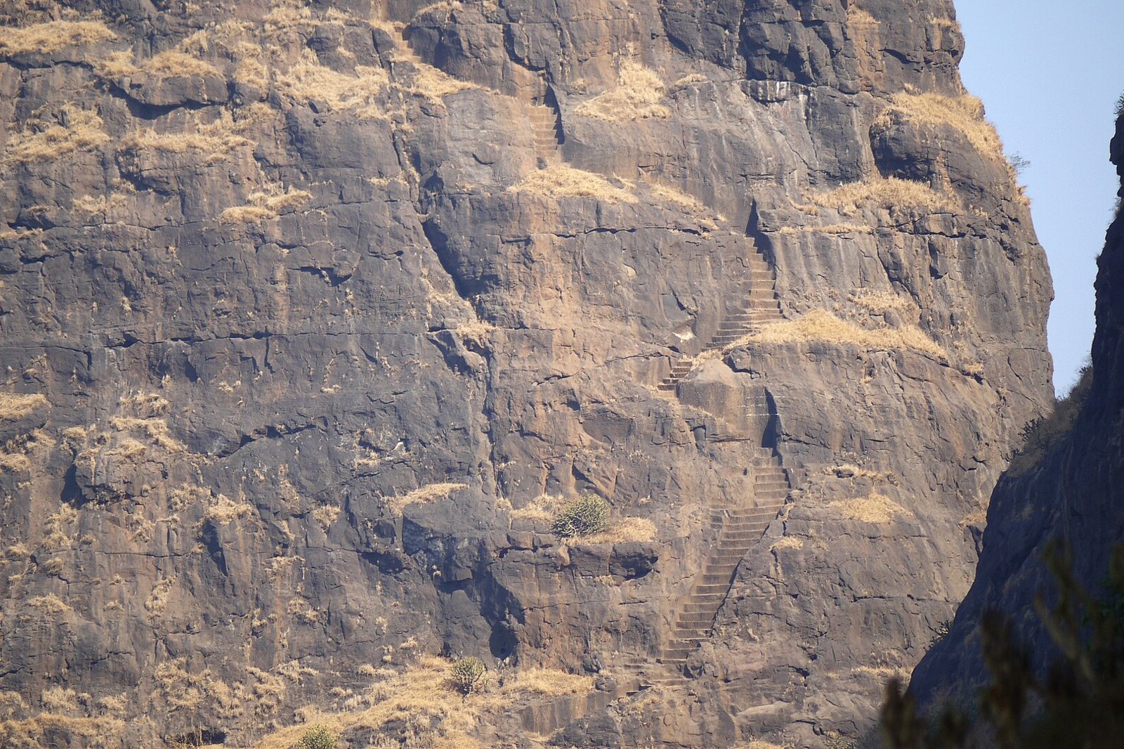
| Rock-cut staircase | Steep steps cut into the rock, with exposure, narrow sections and little room to pass people coming the other way. |
| Final summit scramble | Specialist guides such as Indiahikes and Bikat describe a separate rock obstacle after the steps and caution against attempting it without suitable climbing knowledge. It is optional. Do not treat any rope you find there as maintained or inspected, and do not treat carrying your own rope as a substitute for competent climbing support. |
| Descent | You must go back down the same exposed terrain, often tired and with queues on the narrow sections. |
Wikipedia describes a roughly 60 degree incline and rock-cut steps up to 2 feet high on the climb. Citing news reports, it records serious accidents on treks in this area, including one on the wider Kalavantin and Prabalgad outing in 2016 that is associated with Prabalgad, and a fall near the top of the pinnacle in February 2018.
Access status and historical rules
There are older reports of rules on the hill. They are historical information from 2018, not a verified current rule. After the February 2018 incident, the Hindustan Times reported, as summarised by Wikipedia, that trekkers had to register with the administration and that entry was not allowed between 5 pm and 6 am. It also reported a plastic ban and, separately, a local guide requirement. A May 2024 guide by Muddie Trails says local authorities do not allow trekking in the monsoon because of overcrowding. Other trekking sources describe the monsoon access differently.
Treat the monsoon as unsafe whatever the rules say: the rock is slippery and visibility drops. Whether access is permitted is a separate question, so check before you leave home and reconfirm at the trailhead. Do not plan an evening or night climb.
Getting to Thakurwadi
Panvel is the base. A May 2024 guide says buses run from Panvel towards Thakurwadi, that shared autos are an option and that you can hire an auto from Panvel station. It does not say where the services board or where they drop you, and no timetable could be confirmed for this page. Ask where the vehicle will drop you, and arrange your return before you start. Panvel station and the bus depot are different places.
If you drive, these map distances are from each station to an approximate trek parking point near Thakurwadi, checked on 21 October 2026 with the OSRM routing service on OpenStreetMap data. They are distances, not driving times, and the parking point should be confirmed locally.
| Starting point | Road distance to the Thakurwadi trek parking point |
|---|---|
| Panvel | About 14 km (route) |
| Kharghar | About 21 km (route) |
| CBD Belapur | About 24 km (route) |
| Nerul | About 26 km (route) |
| Vashi | About 31 km (route) |
For trains and the Harbour line connections into Panvel, see the Panvel railway station guide.
Planning the day and the descent
- Choose a clear, dry day. A trek guide suggests starting around 7 am.
- Agree a turnaround time with your group or guide before you start. Work it back from the time you must be at the road, allowing for rest stops, queues on the narrow steps, a slower descent and your return transport.
- Stopping at Prabalmachi, or before the exposed climb, is a worthwhile outing. Reaching the summit is not necessary to have a good day.
- The summit scramble is optional and needs a separate decision on the day, based on conditions, your ability and competent supervision.
- Go with an experienced group or a local guide, and tell someone where you are going and when you expect to return.
- Carry your plastic out, or better, carry none in.
Fees, guides and facilities
Amounts reported in older articles differ and cannot be treated as today’s budget, so this guide does not quote them. Plan for these separate costs, and ask on the day whether each is per person, per group or part of a package:
- Transport to and from Thakurwadi.
- Parking.
- Any local entry or registration charge.
- A guide or an organised-trek charge.
- Food and water.
- Any separately charged help on the summit section.
Toilets, drinking water, food stalls and camping at Thakurwadi and Prabalmachi have not been confirmed for this page. Carry what you need and do not assume a stall or water source will be open.
What to carry
- Hiking shoes with a good grip, since the rock and steps are slippery when wet.
- Plenty of water and snacks, and a small daypack that leaves your hands free.
- A torch and a charged phone, even though you should be down well before dark.
- A basic first aid kit and your own medicines.
For an easier outing, the Karnala Bird Sanctuary guide covers a sanctuary visit, which is not the same as attempting the fort climb. The winter treks guide and the monsoon treks guide include a mix of routes, so check each trek’s difficulty. For longer trips, see the weekend getaways guide.
Frequently Asked Questions
Are Kalavantin Durg and Prabalgad the same trek?
No. They are neighbouring places. The route forks at Prabalmachi, with one path to Prabalgad fort and the other to Kalavantin Durg.
Where does the Kalavantin Durg trek start?
At Thakurwadi village in Panvel taluka, reached from Panvel. Prabalmachi is about 2 km on, according to Wikipedia.
Can I stop at Prabalmachi?
Yes. Stopping there, or before the exposed climb, is a sensible choice depending on conditions and your ability.
Does the final summit section need climbing support?
Specialist guides describe a separate rock obstacle after the steps and caution against attempting it without suitable climbing knowledge. It is optional.
How long is the trek, one way or return?
Wikipedia gives about 3 km to the summit. Sources do not state clearly where it is measured from or whether it is one way, so do not plan from that figure alone.
How difficult is Kalavantin Durg?
It combines an uphill approach, exposed rock-cut steps and a separate final scramble. Wet rock, crowds and the descent make it harder. This guide advises beginners, children and anyone afraid of heights to stay at the lower stages.
Can you trek Kalavantin Durg in the monsoon?
A 2024 guide says local authorities do not allow it, while other sources describe it differently. Avoid wet, low-visibility conditions whatever the rules, and check before you leave.
Can you climb Kalavantin Durg at night?
No. A 2018 report said entry was not allowed between 5 pm and 6 am. That is historical information, but do not plan an evening or night climb.
How do I return to Panvel?
Ask before you start where your vehicle will pick you up, and arrange the return in advance. No timetable could be confirmed for this page.
Sources and a note on accuracy
Checked on 22 October 2026: Wikipedia’s Kalavantin Durg entry, which draws on Mid-Day (10 December 2016), the Hindustan Times (2 July 2018) and Mint (30 March 2017); the Muddie Trails guide of 14 May 2024; and trekking guides by Indiahikes and Bikat for the final section. Reports of rules and fees are historical and may have changed. Map distances are OpenStreetMap estimates from approximate map points. The local legend about a queen named Kalavantin is not confirmed history. Please confirm conditions locally before you climb.
Featured photo: Kalavantin Durg by Dinesh Valke from Thane, India, licensed CC BY-SA 2.0 via Wikimedia Commons, cropped and resized. It shows the rock-cut steps on the pinnacle.
NaviMumbai.com is an independent information site and is not affiliated with any trekking operator or authority.